

Singapore MRT Map: Train Routes, Lines & Travel Guide

Singapore is one of those places that’s easy to enjoy. The streets are super clean, the food choices never end, and the trains make it simple to get around. If you’re visiting, the MRT will be your best way to explore. Just make sure to check the MRT operating hours from Changi Airport so you won’t have to worry about getting stuck late at night.
✨Welcome to Singapore
Enjoy a fun family getaway in Singapore this June with attraction tickets up to 50% off. Book your kids’ day adventure and explore more of the Lion City for less.

📅 Promotion Period: 1 June to 31 August 2026
👍 Save More on USS Tickets!!!
Planning a fun trip to Universal Studios Singapore? Check out these limited-time deals and attraction passes for your Singapore getaway.
- Early Entry & Voucher: Get the Universal Studios Singapore Ticket with Minionland Early Entry, SGD30 Voucher, and Retail 20% Discount Voucher from PHP 6,196. Valid from 18 June to 31 August 2026.
- Buy USS, SGO 50% OFF: Book the Universal Studios Singapore Ticket + Singapore Oceanarium Admission Ticket from PHP 4,882. Valid from 16 June to 15 July 2026.
- Group Travel: 15% OFF: Traveling with friends or family? Get the USS Group Admission Ticket for 3 to 4 people from PHP 3,312. Valid from 12 June to 31 August 2026.
- USS Admission Ticket with Free Vouchers: Get the USS Admission Ticket with Free SGD5 F&B Voucher + SGD5 Retail Voucher from PHP 3,344. Valid from 1 June to 31 August 2026.
Overview of the Singapore MRT Lines

Source: Land Transport Authority Singapore
When you step into an MRT station in Singapore, you’ll see how easy it is to get around. The MRT map connects almost every corner of the island, from busy shopping areas to tourist spots and even quiet neighbourhoods. Each line has its own route, so knowing them will help you plan your trip better and save time while exploring.
MRT Line | Color | Main Route | Useful Tourist Stops |
|---|---|---|---|
North-South Line | Red | Jurong East to Marina South Pier | Orchard, City Hall, Raffles Place, Marina Bay |
East-West Line | Green | Pasir Ris to Tuas Link, with Changi Airport branch | Changi Airport, Bugis, City Hall, Jurong East |
Circle Line | Orange | Circle around central Singapore with Dhoby Ghaut branch | HarbourFront, Botanic Gardens, Esplanade, Marina Bay |
North East Line | Purple | HarbourFront to Punggol Coast | Chinatown, Clarke Quay, Little India, Punggol Coast |
Thomson-East Coast Line | Brown | Woodlands North to Bayshore | Orchard, Maxwell, Gardens by the Bay, Marine Parade |
Downtown Line | Blue | Bukit Panjang to Expo | Botanic Gardens, Little India, Bugis, Bayfront, Chinatown |
North-South Line (Red Line)
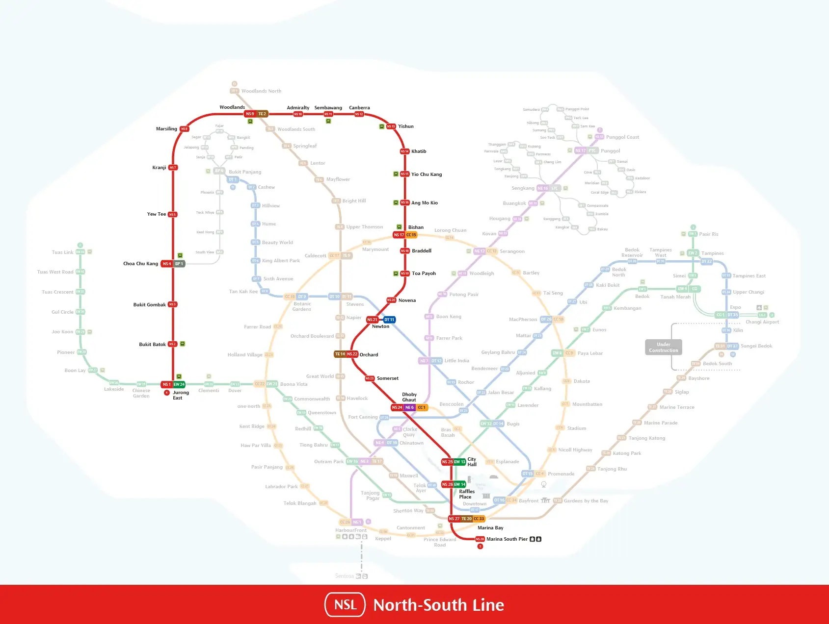
Source: Land Transport Authority Singapore
The North-South Line runs between Jurong East and Marina South Pier. It passes through northern Singapore before travelling south through Orchard Road, the Civic District, the Central Business District, and Marina Bay.
Useful stations include:
- Orchard Station: Orchard Road, ION Orchard, and nearby shopping malls
- Dhoby Ghaut Station: Plaza Singapura, Fort Canning Park, and the National Museum of Singapore
- City Hall Station: National Gallery Singapore, St Andrew’s Cathedral, and the Civic District
- Raffles Place Station: Merlion Park, Boat Quay, and the Central Business District
- Marina Bay Station: Marina Bay attractions and connections to the Circle and Thomson-East Coast lines
East-West Line (Green Line)
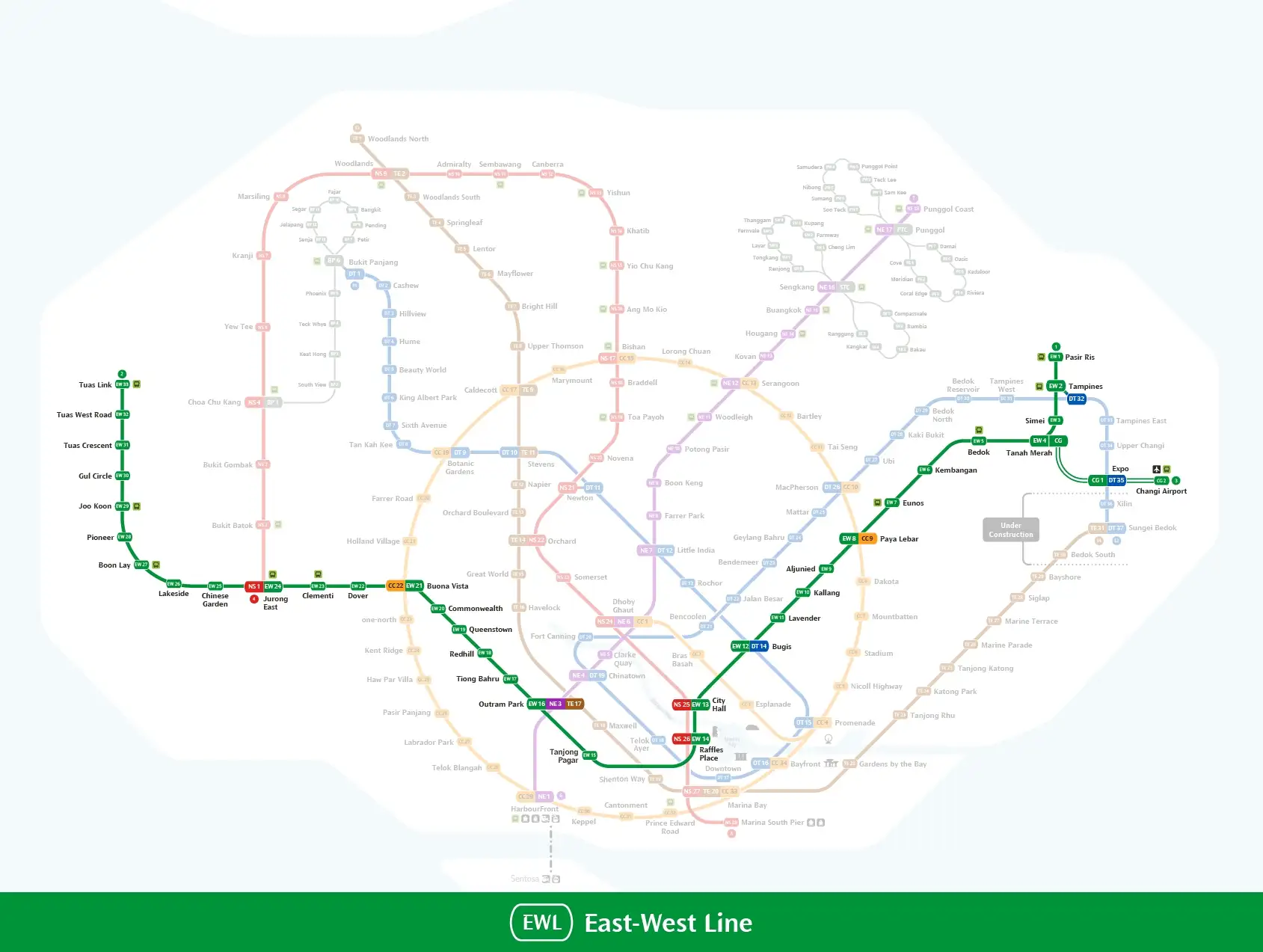
Source: Land Transport Authority Singapore
The East-West Line runs between Pasir Ris and Tuas Link. A separate branch connects Tanah Merah, Expo, and Changi Airport.
This line is useful for travelers staying near Bugis, City Hall, Lavender, Tiong Bahru, or Jurong East. Passengers arriving at Changi Airport must transfer at Tanah Merah or Expo to continue towards central Singapore.
Useful stations include:
- Changi Airport Station: Terminals 2 and 3, with access to Jewel Changi Airport
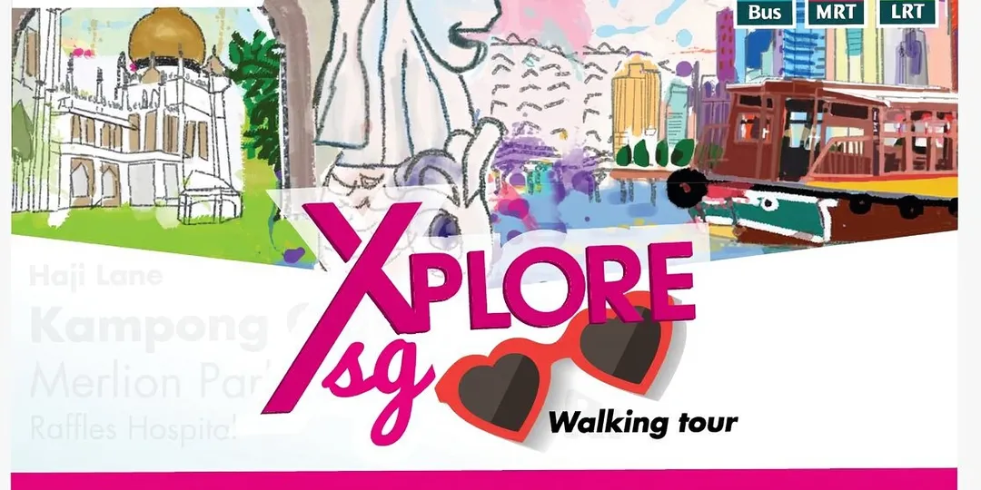
- Bugis Station: Bugis Street, Haji Lane, Arab Street, and Kampong Glam
- City Hall Station: National Gallery Singapore, CHIJMES, and the Esplanade area
- Tiong Bahru Station: Tiong Bahru Market and nearby cafés
- Jurong East Station: Science Centre Singapore, JEM, Westgate, and IMM
Circle Line (Yellow Line)
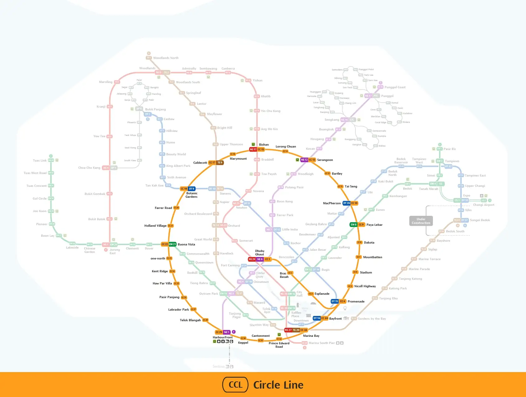
Source: Land Transport Authority Singapore
The Circle Line connects major areas around central Singapore, including HarbourFront, Botanic Gardens, Paya Lebar, Marina Bay, and the National Stadium.
Circle Line Stage 6 opened on 12 July 2026 with three new stations:
- Keppel Station (CC30)
- Cantonment Station (CC31)
- Prince Edward Road Station (CC32)
These stations connect HarbourFront and Marina Bay, completing the main Circle Line loop. The completed line provides more routes around the city without requiring passengers to transfer at City Hall or Raffles Place.
Useful stations include:
- HarbourFront Station: VivoCity, Sentosa Express, cable car, and Sentosa Island
- Botanic Gardens Station: Singapore Botanic Gardens and National Orchid Garden
- Esplanade Station: Esplanade, Marina Bay, and Suntec City
- Stadium Station: Singapore Sports Hub and Kallang Wave Mall
- Marina Bay Station: Marina Bay area and connections to other MRT lines
North-East Line (Purple Line)
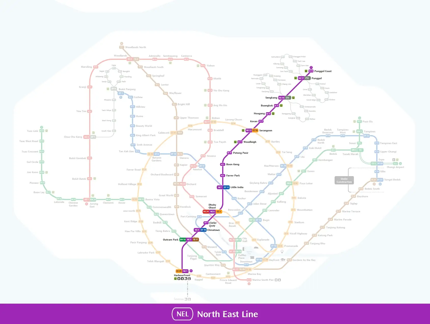
The North East Line now runs between HarbourFront and Punggol Coast. The old endpoint was Punggol, but the line was extended to Punggol Coast in December 2024.
The line passes through several popular cultural and entertainment districts.
Useful stations include:
- HarbourFront Station: VivoCity and Sentosa Island
- Chinatown Station: Chinatown, Buddha Tooth Relic Temple, and Chinatown Complex
- Clarke Quay Station: Singapore River, Clarke Quay, and Boat Quay
- Little India Station: Little India Arcade, Tekka Centre, and nearby temples
- Punggol Coast Station: Punggol Digital District, Singapore Institute of Technology, and the northern Punggol area
Thomson-East Coast Line (Brown Line)
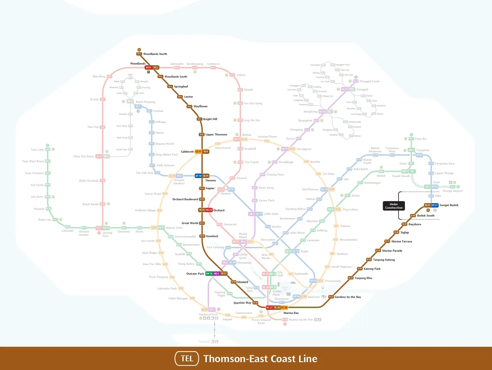
Source: Land Transport Authority Singapore
The Thomson-East Coast Line currently runs from Woodlands North to Bayshore. It connects northern Singapore with Orchard Road, Marina Bay, Gardens by the Bay, Marine Parade, and the East Coast.
Stage 5 has not opened yet. Bedok South and Sungei Bedok stations are scheduled to open in the second half of 2026, according to the official LTA Thomson-East Coast Line plan.
Useful stations include:
- Woodlands North Station: Future connection to the Johor Bahru-Singapore RTS Link
- Orchard Station: Orchard Road and ION Orchard
- Maxwell Station: Maxwell Food Centre, Chinatown, and Buddha Tooth Relic Temple
- Gardens by the Bay Station: Gardens by the Bay and Marina Barrage
- Marine Parade Station: Parkway Parade and access to East Coast Park
- Bayshore Station: Bayshore neighbourhood and East Coast Park
Downtown Line (Dark Blue Line)
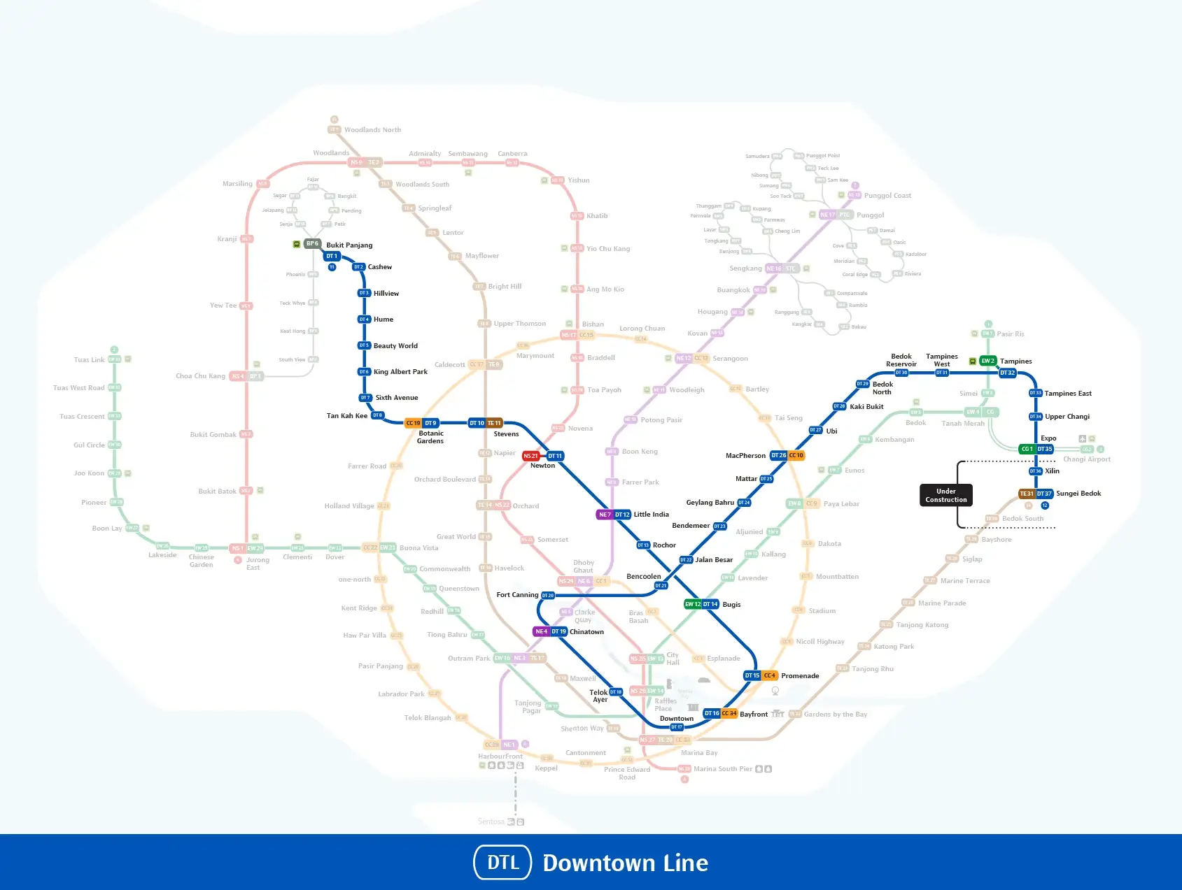
Source: Land Transport Authority Singapore
The Downtown Line runs between Bukit Panjang and Expo. It has 35 operating stations following the opening of Hume Station on 28 February 2025.
The line is useful for reaching Bukit Timah, Botanic Gardens, Little India, Bugis, Chinatown, Marina Bay, Tampines, and Expo.
Useful stations include:
- Hume Station: Rail Corridor and Former Ford Factory
- Beauty World Station: Bukit Timah Nature Reserve and Beauty World Centre
- Botanic Gardens Station: Singapore Botanic Gardens
- Little India Station: Little India and Tekka Centre
- Bugis Station: Bugis Street and Kampong Glam
- Bayfront Station: Marina Bay Sands, ArtScience Museum, and Gardens by the Bay
- Chinatown Station: Chinatown and nearby heritage attractions
- Expo Station: Singapore EXPO and Changi Business Park
The Downtown Line extension to Xilin and Sungei Bedok is scheduled to open in the second half of 2026.
Future Singapore MRT Lines and Extensions
Johor Bahru-Singapore RTS Link
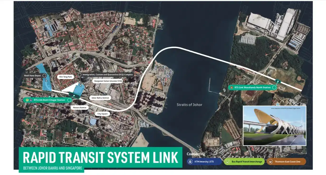
Sources: MRT Corp
The RTS Link is targeted to begin passenger service at the end of 2026. It will connect Woodlands North in Singapore with Bukit Chagar in Johor Bahru. The train journey will take about five minutes, excluding immigration processing. View the official RTS Link project.
Jurong Region Line
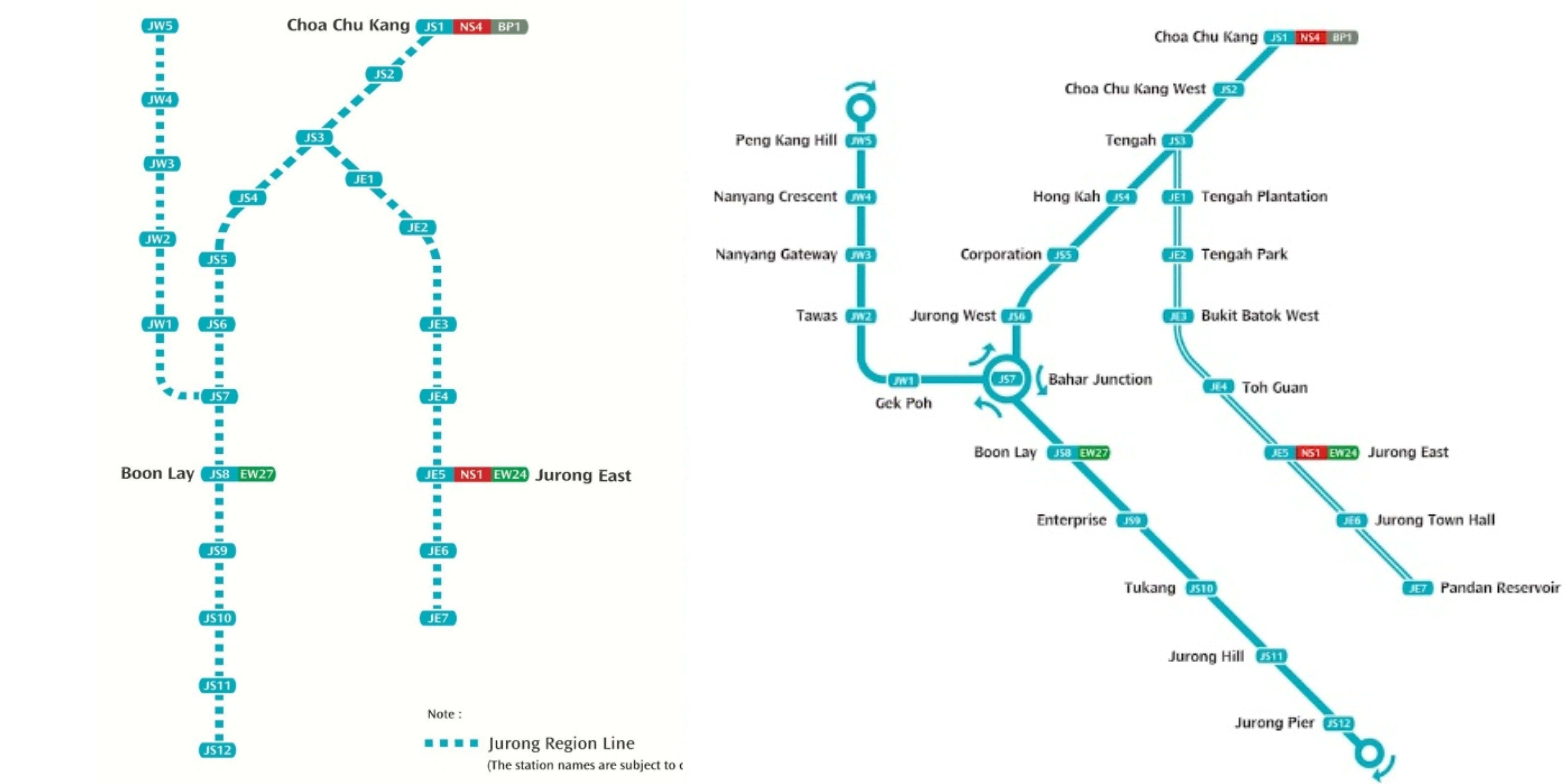
Source: Land Transport Authority Singapore
The Jurong Region Line will improve transport around Tengah, Jurong East, Boon Lay, Jurong Industrial Estate, and Nanyang Technological University. Stage 1 is now expected to open around mid-2028.
Cross Island Line
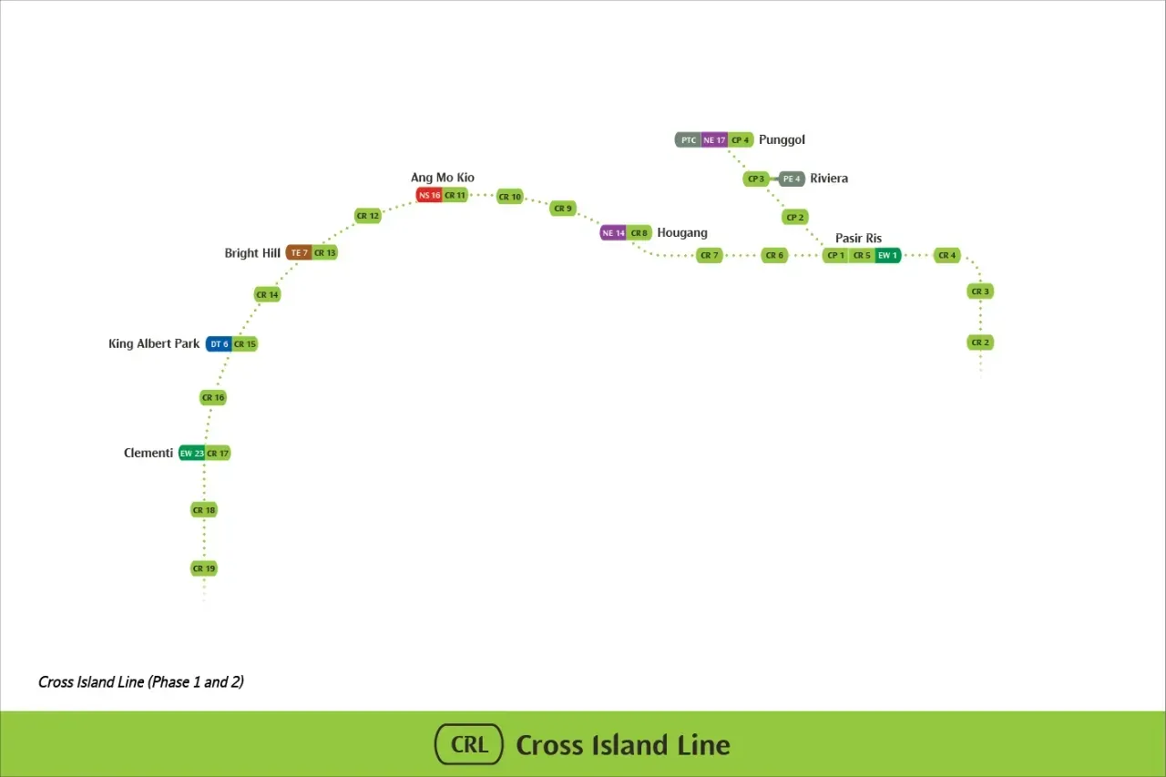
Source: Land Transport Authority Singapore
The Cross Island Line will connect the Changi region with Pasir Ris, Hougang, Ang Mo Kio, Bright Hill, Clementi, and Jurong Lake District. Phase 1 is targeted for completion in 2030, while Phase 2 and the Punggol Extension are expected by 2032.
Singapore MRT Fares and Tickets
Singapore’s train fares are calculated according to the total distance traveled. Adult MRT and LRT card fares currently range from S$1.28 to S$2.57, around ₱61 to ₱123.
Passengers who tap in before 7:45 AM on weekdays, excluding public holidays, receive a S$0.50 discount. Early-morning fares range from S$0.78 to S$2.07, around ₱37 to ₱99. These rates took effect on 27 December 2025.
Exchange rates are approximate and may change.
How to Pay for Singapore MRT Rides
Single-trip MRT tickets have been phased out. Travelers can pay using:
- SimplyGo EZ-Link card
- NETS Prepaid card
- Contactless Visa, Mastercard, or American Express card
- Apple Pay, Google Pay, or Samsung Pay
- Singapore Tourist Pass
Always use the same card or mobile device when tapping in and out. A physical bank card and the same card stored in a mobile wallet are treated as different payment methods.
Filipino travelers using a foreign-issued Visa or Mastercard will be charged an additional S$0.60 foreign bank card administration fee for each day the card is used.
Secure Your Stay in Singapore
 NO.1
NO.1


Singapore MRT Operating Hours
Most MRT stations in Singapore open early and close around midnight, making it convenient for both locals and tourists.
- First train: Around 5:30 a.m. from most stations
- Last train: Around 12:00 a.m. (midnight)
On special occasions like New Year's Eve, the eve of public holidays, or during big events, the MRT may extend its operating hours. Do note that some lines or specific sections can have slightly different timings, so it's always good to check before you travel late at night. Also, if you commute on weekdays, tapping in before 7:45 AM qualifies you for a S$0.50 off-peak discount — a handy way to save on your daily rides.
Unlock the Best Flights to Singapore
EZ-Link Card
To get around Singapore easily, you’ll need an EZ-Link card. You can buy it at MRT station counters, and it works on trains, buses, and even some other transport.
Visitors can choose between a single-trip ticket or a stored-value EZ-Link card that you can top up anytime. With this, traveling to places like Gardens by the Bay, Orchard Road, or a nearby hawker centre becomes smooth and convenient.
Getting Around Singapore Made Easy
For Filipinos visiting Singapore, the MRT is one of the smartest ways to move around the city. With an EZ-Link card, you can ride trains and buses without the hassle of buying tickets every trip. It saves time and money, especially if you plan to visit several places in a day. The MRT brings you close to top spots like Orchard Road for shopping, Chinatown and Little India for culture, and Gardens by the Bay for a relaxing walk. Riding the MRT feels simple and reliable, making it easy to enjoy Singapore even if it’s your first time visiting.
❓FAQs: Singapore MRT Map
-
Is the MRT map easy to understand?
-
How do I know which MRT line to take?
-
Does the MRT map show tourist attractions?
-
What ticket should I use?
-
Can I go to Changi Airport using MRT?
Trending Searches
-
Featured guides
-
Trip.com links